
dielmo maps
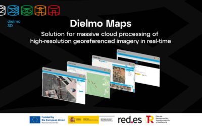
Dielmo Maps destaca como la opción SaaS basada en la nube más asequible para la creación de geoportales web y su posterior compartición, ya sea para uso interno o público. Ofrece un completo conjunto de funcionalidades que incluye un gestor de contenidos, herramientas para inspección visual y creación de informes personalizados, procesamiento de datos espaciales en la nube, inteligencia artificial, acceso a sensores en tiempo real, así como datos LiDAR, entre otras prestaciones.
acccede a la plataforma en tu región preferida
solución destinada a

organismos públicos
Cualquier organismo público que gestiona datos geoespaciales y desea compartirlos de forma pública o privada. Ayuntamientos, diputaciones, institutos cartográficos, confederaciones hidrográficas, medio ambiente, transporte, emergencias, etc.

ingenierías
Mantenimiento de infraestructuras, inventario de infraestructuras, inspección visual de activos, ingenierías, empresas de captura de datos, cualquier empresa que gestiona datos geoespaciales.

agricultura
Acceso sencillo a índices de vegetación creados a partir de imágenes de satélite o vuelos con dron de diferentes fechas, para el análisis del rendimiento de los cultivos.
sive para

visualizar datos geoespaciales en web
Acceso rápido a toda la información geoespacial de forma sencilla desde web sin necesidad de otros softwares específicos, con seguridad en el acceso a los datos y controlando el dato que se publica en cada momento.

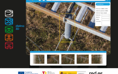
inspección visual de imágenes o videos
Herramienta perfecta para acelerar la inspección visual con imágenes de alta resolución o videos georeferenciados. Generación automática y personalizada de informes. Detección de objetos con inteligencia artificial.
algunas funcionalidades
panel de búsqueda
Permite realizar búsquedas por nuestros puntos de interés, código catastral, árbol de vistas o nombres de calle.
obtener elevación
Permite obtener la elevación en cualquier punto del mapa con un modelo de elevaciones personalizado y preciso.
fotos 360º
Permite acceder a fotos 360º que publique el propio usuario con herramientas de inspección visual o las de google street view.
información catastral
Permite acceder de forma rápida y sencilla a información catastral, pinchando en un punto o buscando por referencia catastral.
coordenadas
Permite obtener las coordenadas exactas de un punto en el mapa o ir a las coordenadas deseadas.
mediciones
Permite realizar mediciones lineales o de superficie sobre el mapa. También podemos medir sobre perfiles LiDAR o en 3D.
acceso a sensores
Podemos integrar APIs de terceros para consultar información de todo tipo de sensores en el mapa y pintarlos en función del valor.
datos LiDAR online
Permite acceder de forma rápida y sencilla a datos LiDAR de diferentes fechas mediante perfiles y visualización en 3D
inspección visual
Avanzada herramienta de inspección visual para analizar y generar informes personalizados a partir de imágenes y videos de alta resolución.
componentes

gestor de contenidos
El gestor de contenidos permite personalizar y crear nuevas capas dentro de Dielmo Maps, crear y editar nuevos Mapas Web y modificar su visibilidad, poder gestionar el acceso a los datos mediante roles, permisos y zonas de administración, y poder conectar con bases de datos existentes para mostrar capas.

visor LiDAR
La función avanzada del visor LiDAR, nos permite seleccionar un área y visualizarla a través de los datos LiDAR obtenidos en una o varias fechas diferentes, mediante perfiles o en 3D, con herramientas de medición, diferentes estilos de visualización, y opciones de importación y exportación de datos en formato LAS.
La nueva versión de Dielmo Maps es el resultado de nuestro último proyecto de investigación. DIELMO 3D, ha sido beneficiaria del proyecto 2021/C005/00146211 subvencionado por el Ministerio de Transformación Digital, a través de la entidad Red.es, cuyo objetivo ha sido la abordar retos complejos de la sociedad, mediante el desarrollo experimental de soluciones apoyadas en diferentes tecnologías digitales, tales como computación en la nube, tecnologías de procesamiento masivo de datos e información e inteligencia artificial.
Título del proyecto: Solución para procesamiento masivo en la nube de fotografías georreferenciadas de alta resolución a tiempo real.

últimas entradas al blog
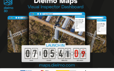
Cuenta atrás para el lanzamiento de la plataforma SaaS Dielmo maps en el Energy Drone & Robotics Summit, Junio 2024, Houston
Dielmo Maps, la nueva plataforma SaaS de procesamiento de datos geoespaciales de alta resolución basada en la nube, está a punto de estar disponible para el público. Este lanzamiento se llevará a cabo en el Energy Drone & Robotics Summit en Houston, del 10 al 12...
Factores diferenciales que hacen única a nuestra nueva plataforma Dielmo maps
En DIELMO 3D llevamos más de 15 años trabajando en el desarrollo de tecnologías para la publicación de datos espaciales a través de internet. Por ejemplo, en 2010 ya disponíamos de nuestra tecnología para la publicación de datos LiDAR mediante una herramienta de...
Presentamos Dielmo Maps como servicio SaaS en GEO WEEK 2024
Un año más Dielmo 3D participará en GEO WEEK 2024, donde estamos presentes desde 2010. Será en el Centro de Convenciones de Colorado, Denver (EEUU). Dielmo 3D presentará la nueva versión de Dielmo Maps, nuestro nuevo servicio SaaS basado en la nube que ofrece...